List of loaded documents (1-36 / 118)
-
1. Digital Post-Disaster Risk Management Twinning: A Review and Improved Conceptual Framework
-
2. Mainstreaming Disaster Risk Reduction into Development: Effectiveness of DRR Investment in Khyber Pakhtunkhwa, Pakistan
-
3. Emerging Trends in Disaster Risk Reduction and Climate Change Adaptation Higher Education
-
4. The missing half of the Sendai framework: Gender and women in the implementation of global disaster risk reduction policy
-
5. Understanding and Mitigating Urban Flood Risk
-
6. Landslide susceptibility mapping using GIS-based statistical models and Remote Sensing in the Kathmandu valley, Nepal
-
7. Landslide Hazard Mapping Along the Beni-Lete Road Section, Myagdi-Mustang Districts, Western Nepal
-
8. Addressing capacities of local communities in a changing context in Nepal
-
9. Landslide Susceptibility Mapping with GIS in Nagi Dada Area of Panauti Municipality, Kavrepalanchwok District: A Comparison Between AHP and FR Method
-
10. Spatial analysis of causative factors for landslide susceptibility mapping in parts of Makwanpur District, central Nepal
-
11. Review of landslide inventories for Nepal between 2010 and 2021 reveals data gaps in global landslide hotspot
-
12. Rockfall susceptibility along Pasang Lhamu and Galchhi-Rasuwagadhi highways, Rasuwa, Central Nepal
-
13. Challenges of Implementing Disaster Risk Reduction Activities by Local Governments: A Case Study of Shankharapur Municipality in Kathmandu Valley, Nepal
-
14. Change in policy regimes for disaster risk reduction in Fiji and Nepal
-
15. Developing disaster risk reduction skills among informal construction workers in Nepal
-
16. Benchmarking Community Disaster Resilience in Nepal
-
17. Landslide susceptibility mapping in eastern hills of Rara Lake, Western Nepal
-
18. Issues and Challenges in the 2015 Nepal Earthquake Response
-
19. Ecosystem restoration reduces community vulnerability to water-induced disasters: Need to rethink Chure conservation in Nepal
-
20. Importance of bamboo for immediate earthquake recovery: A study from Nepal
-
21. Shifting Power Through Participation in Post-Disaster Recovery: A Scoping Review
-
22. Gendered Impacts of Climate Change: Evidence from Weather Shocks
-
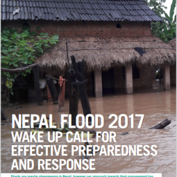
23. Nepal Flood 2017 Wake up Call for Effective Preparedness and Response
-
24. Lightning Threats in Nepal: Occurrence and Human Impacts
-
25. How can LGBTQIA+ people be engaged in Disaster Risk Reduction policy-making without compromising safety?
-
26. Landslide Susceptibility and Risk Analysis in Benighat Rural Municipality, Dhading, Nepal
-
27. CATALYZING CHANGE FOR RESILIENCE ACROSS BOUNDARIES: CHALLENGES IN NEPAL'S SMALL TRANSBOUNDARY RIVERS
-
28. A Review of Studies on Community Based Early Warning Systems
-
29. Community-Based Approach to Flood Early Warning in West Rapti River Basin of Nepal
-
30. A GIS-based Comparative Evaluation of Analytical Hierarchy Process and Frequency Ratio Models for Landslide Susceptibility Mapping
-
31. Landslide Hazard Assessment Between Besi Sahar and Tal Area in Marsyangdi River Basin, West Nepal
-
32. Evaluating Underlying Causative Factors for Earthquake-induced Landslides and Landslide Susceptibility Mapping in Upper Indrawati Watershed, Nepal
-
33. GIS-Based Landslide Susceptibility Modeling: A Comparison Between Fuzzy Multi-criteria and Machine Learning Algorithms
-
34. Landslide Susceptibility Analysis of Shiv-khola Watershed, Darjeeling: A Remote Sensing and GIS-Based Analytical Hierarchy Process (AHP)
-
35. Landslide Hazard Mapping: GIS Based Susceptibility Assessment of Leoutikhola Watershed, Dhankuta, Nepal
-
36. GIS-Based Weights of Evidence Modeling of Rainfall-induced Landslides in Small Catchments for Landslide Susceptibility Mapping